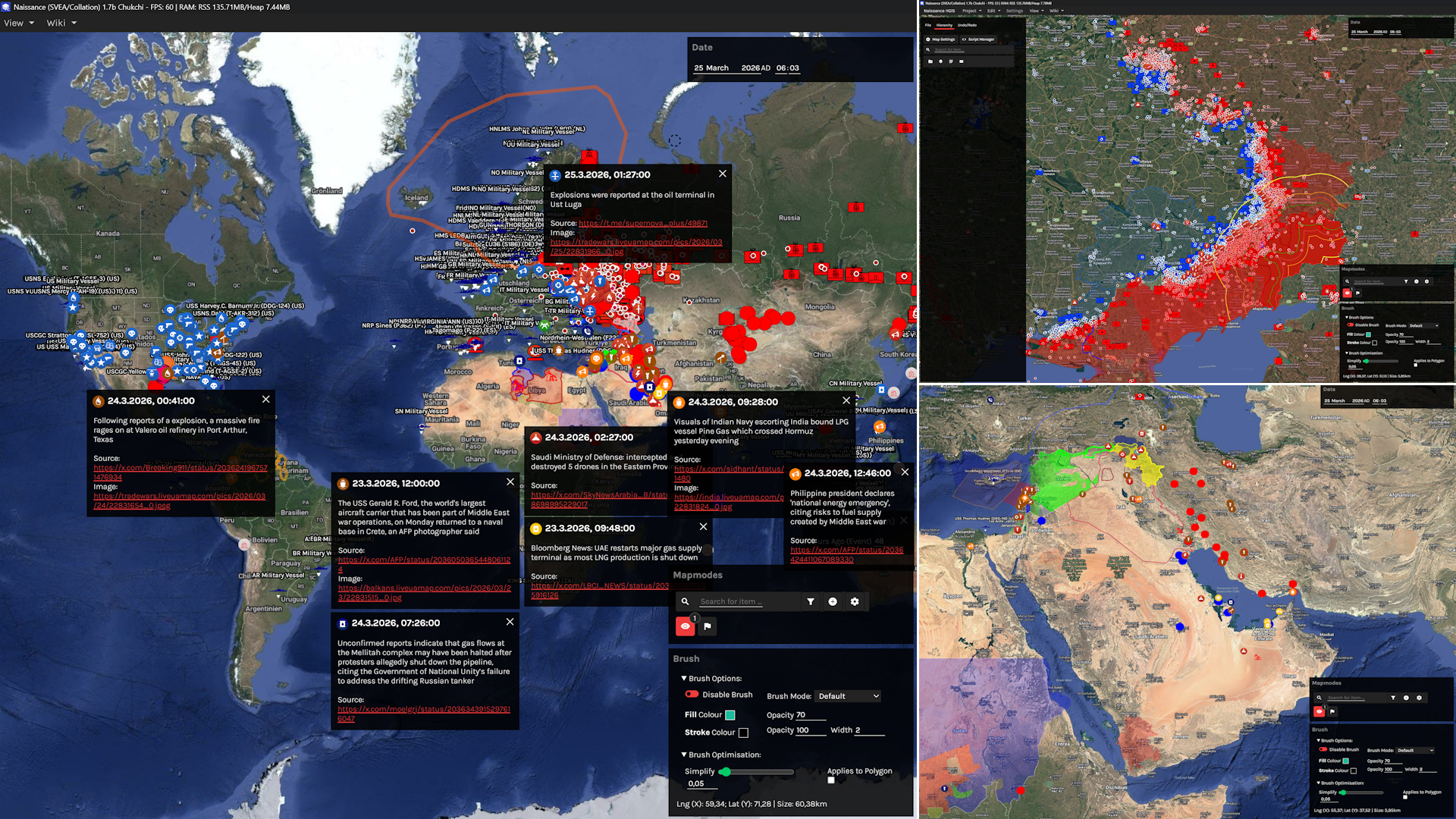
Collation/Livemap with ORBATs, events, and naval data.
(World/Ukraine/MidEast) 25 March 2026. |
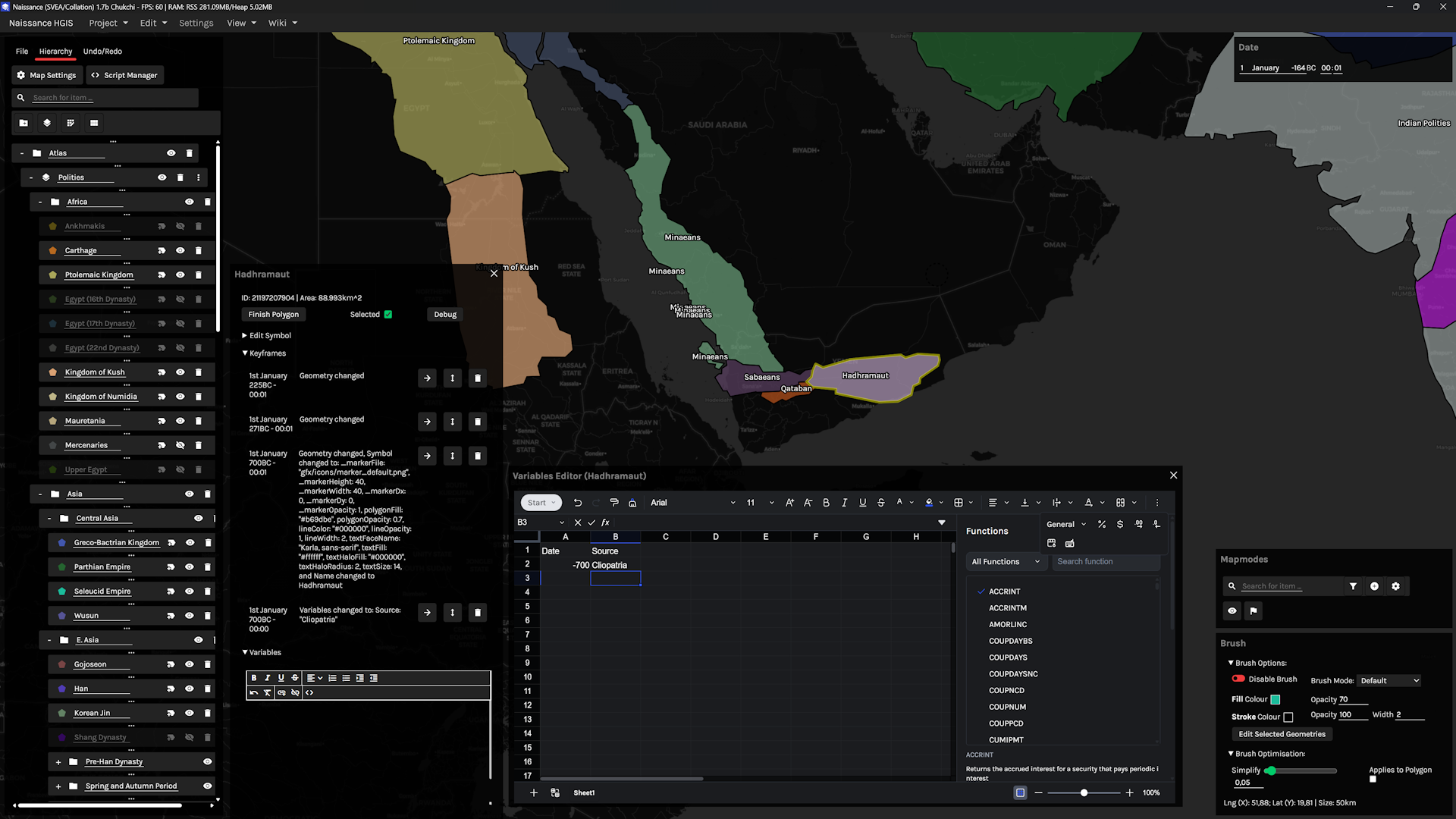
Spreadsheet/keyframes for Naissance geometries.
(Atlas) 1 January 164BC. |
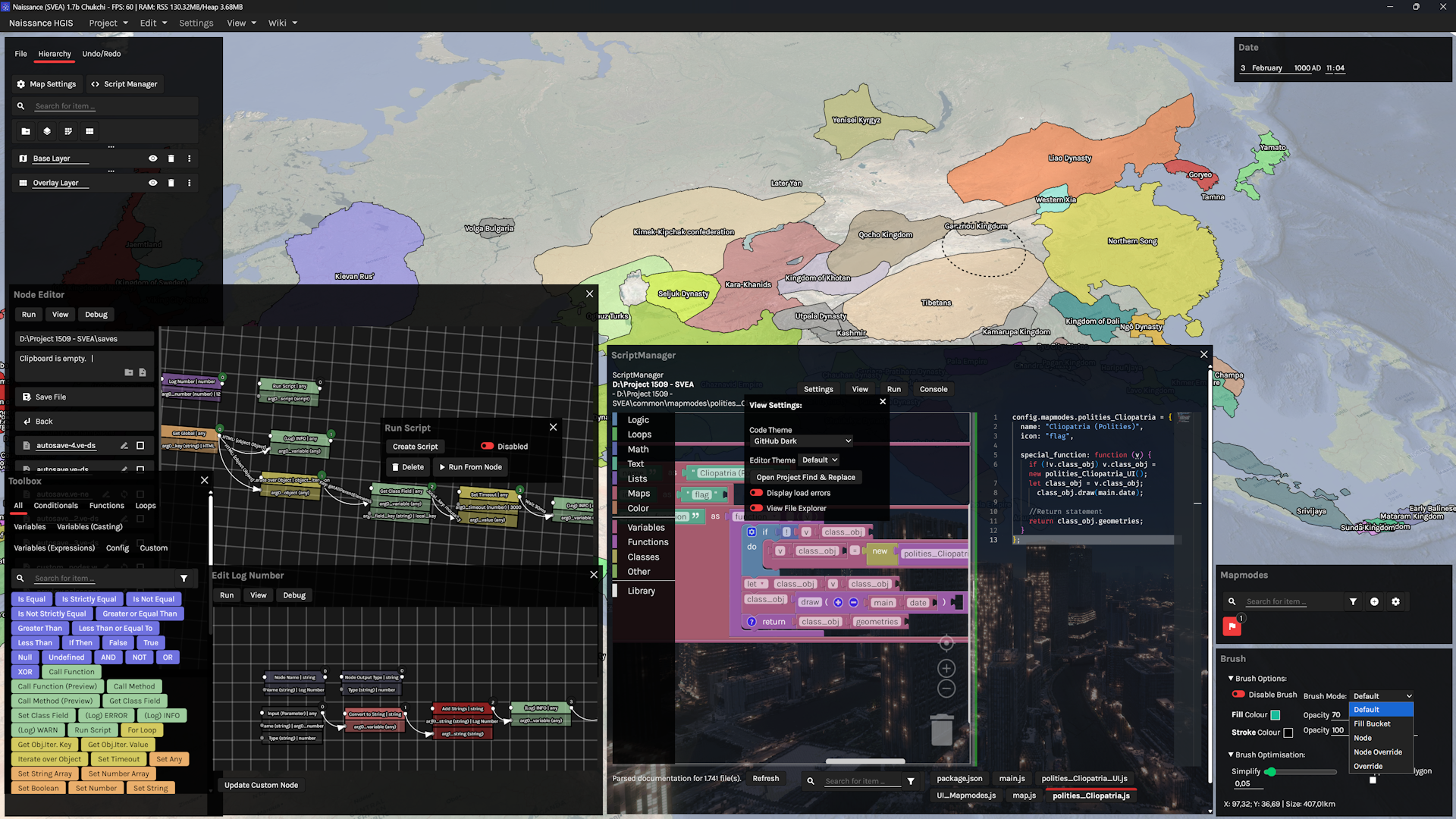
Visual scripting between Nodes <-> Blocks <-> Code.
All 3 are transpiled by Naissance's IDE. |
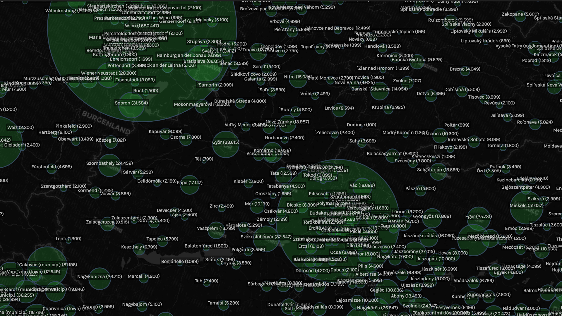
City populations in Austria-Hungary.
(Stadestér/Velkscala) 31 December 1900. |
- E-mail: vf@confoederatio.org
- Documentation (Naissance): confoederatiodocs.info
- Documentation (Vercengen): confoederatio.org/Vercengen
Note
This repository contains production builds for Naissance HGIS. If you require leading capabilities, including pre-packaged Livemap/Histmap scripts, consider using Naissance Collation instead.
Naissance HGIS is a 3D map editor for geospatial data with a focus on ease-of-use and capability. History is managed via keyframes, and a ground-up Undo/Redo Tree system allows for branches, merges, and commits. Users can create groups, layers, overlays, and utilise brushes much like in traditional raster editing programs in addition to traditional vector-based editing tools.
Note. Most of the dev builds are built for Windows, since that's what most use. If you are on MacOS/Linux and need tech support, please join the Discord.
Stable Release (1.8.3, Windows):
- Download Naissance 1.8.3b
- Extract ZIP file when downloaded.
- Run
naissance.exe.
Latest Dev Build or MacOS/Linux:
- Download Node.JS if not installed: https://nodejs.org/en/download
- Click
Code>Download ZIP> Extract ZIP file when downloaded. - Run
autorun.batif on Windows. If on MacOS/Linux, runautorun.sh.
To get the most out of Naissance's built-in visual scripting and custom UI capabilities, you may find it useful to familiarise yourself with our software engine, Vercengen. This is bundled with Naissance, and you do not have to install it separately.
Maps are saved as .naissance files, or in the case of Livemaps, as mapmodes with associated Workers. As such, they are denoted as either being:
- Livemaps, which produce Ontology streams from Blacktraffic Workers, with built-in scraping and processing APIs, and are used for real-time data.
- Histmaps, which are historical to near-real time data that do not require live processes. They typically rely on local save files and the built-in keyframe system.
Naissance HGIS is compatible with anything in the npm, Python (both regular pip and .ipynb notebooks), and R ecosystems via Vercengen. UI components are additionally just as extensible, as they need only store an .element: HTMLElement and .v (state value), and can be composed on the fly. Since it is Electron-based, it slots into native web map libraries unlike legacy GIS.
These libraries and utils can also be used in the visual script editor (alongside GDAL/GRASS/Magick/SAGA if they are installed). ASC, GeoJSON, GeoPNG, GeoTIFF, KMZ/KML, NC, and other file formats are supported by default; alongside Proj4JS live-warping. Blacktraffic scrapers rely on Chrome (Puppeteer) and Firefox (Selenium) and can capture Deck.gl, Leaflet, MapLibre, Maptalks and OpenLayers geometries.
3D geometries beyond 2.5D rely on .gltf files and 3D Tiles (ideally via Blender), with full Three.js support.
For ready-made data analysis, you may find it useful to use Confoederatio histmaps/livemaps instead. We typically refer to the collection of all our datasets as the Naissance World Model, which is divided as follows alongside corresponding metadata.
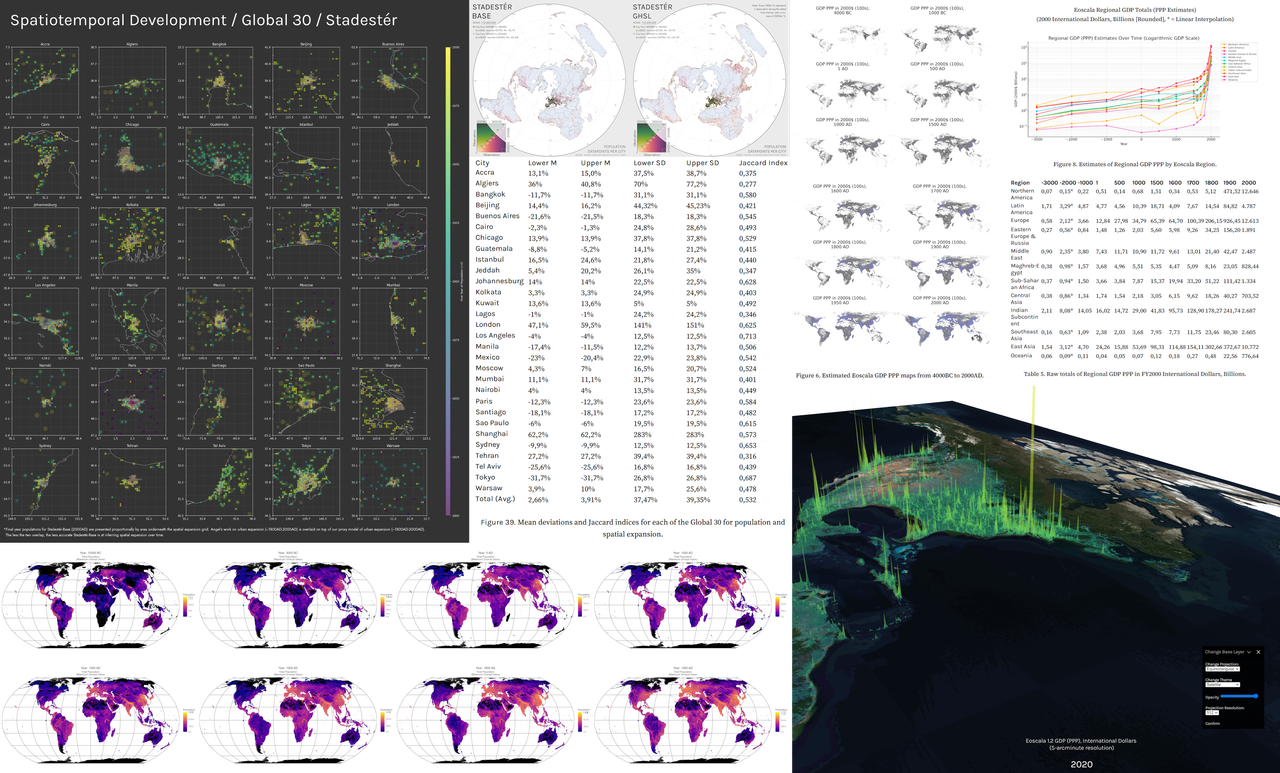
Left: Selected population, urban growth, and sampling data from Stadestér/Velkscala, alongside testing and validation benchmarks.
Right: Estimated GDP PPP data from Eoscala (3000BC-2020AD)
Note. Stadestér refers to urban data, whereas Velkscala refers to population data generally, including ALCC/LU models.
- Atlas: (Vector) - De facto polity extents from 3000BC-2014AD, GeoJSON. Sub-yearly resolution. De jure polity extents from C-Shapes 2.0.
- Eoscala: (Raster) - Economic estimates (GDP PPP) from 10000BC-2023AD, (Gini) from 21500BC-1800AD [point-based] at 5-arcmin resolution; Gapminder provides Gini past 1800AD here.
- Stadestér/Velkscala: (Raster/Vector) - Population estimates (rural, urban, total), land use and ALCC (from HYDE/LUH2KK10) from 10000BC-2025AD. Urban extents and locations are given as GeoJSON datasets, with individual pop. estimates for 41k+ cities between 3000BC-2025AD. Yearly urban extents are made available from 1800AD cities. 5-arcmin resolution.
- Collation (Vector) - ORBATs, territorial control, and geospatialised news aggregation. Scripts for self-hosting are available here.
- Deprojector (Beta; Raster) - Arbitrary projection-to-projection georeferencing using ML. These scripts are currently a proof-of-concept and not recommended for production.